- Picnic areas
- »

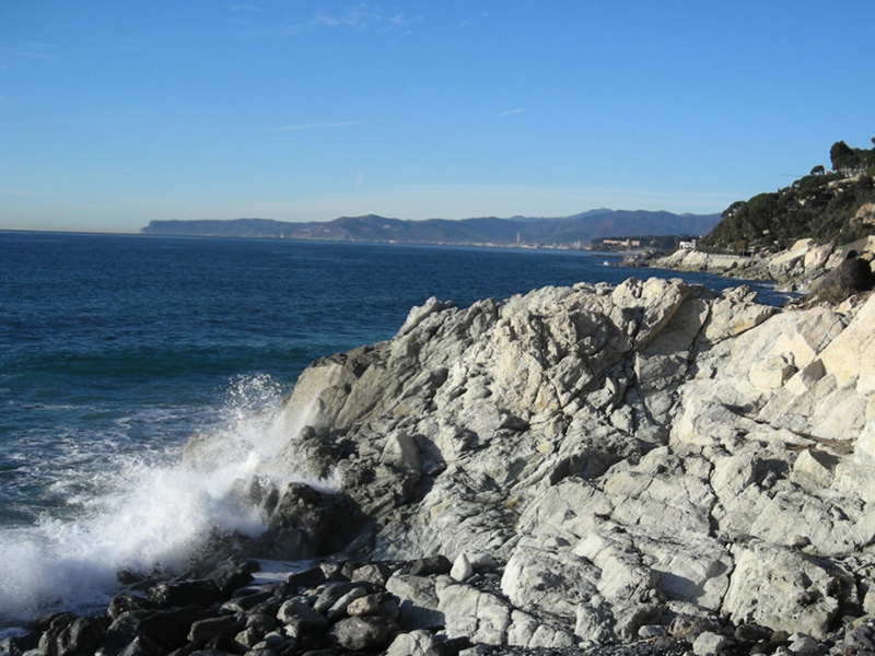
This easy itinerary runs through a coastal stretch of the Riviera Ligure di Ponente (Western Ligurian Riviera) for almost 4 km between the town of Varazze, in the south west and that of
Cogoleto in the north east. This is a wide, flat route, known as the Parco Costiero dei Piani d’Invrea (Coastal Park of Piani d’Invrea) - viale Europa, and it occupies the old railway built at the end of the nineteenth century. It is a lovely coastal tract, enjoyable in every season and characterised by a
frequent succession of rocky coves jutting out into the colourful sea rich with life.
Along the route you will have the chance to discover some of the geological and geo-morphological of the Beigua Geopark, such as the marks indicating the variations in the sea levels in the past or
those related to the tectonic movements that shaped this land.
The promenade itself was built on small flat strips that formed on the rocky promontories due to the levelling by the wave motion in the past. Along the walk you will come across many spots where the presence of level areas on the slope and of round pebbles in the land above them allow
you to identify the level of the sea in the past (today up to 100 metres above the sea).
The flat area where the highway runs today corresponds to one of these spots, indicating the level that the sea reached in the past: 100 meters above the present level.

 Download KMZ
  Download the GPX format
Observing the cliffs while you walk you will notice that the rocks that form them change notably,
originating the local terms “gianchi” and “negri” (white and black, in the local dialect). Around Varazze the coastal strip is made up of pale coloured rocks, called “meta-gabbros” with greenish patches (pyroxene minerals) mixed to prevalently whitish ones (plagioclase minerals).
Approaching Cogoleto, the cliffs suddenly become very dark, almost black, pointing out a different
substratum, characterised by rocks rich in ferrous minerals, called “serpentinite”. A close look to these metamorphic rocks reveals a more or less dark green colour, among which the naked eye can hardly notice and discern the composing minerals: the light green of the “serpentine” mineral
and the black of the “magnetite”. Almost in Cogoleto, inside the Bagni Mizar, on a rocky promontory
protruding into the sea we can observe an almost unique testimony of the level of the sea at +7 m.
a.m.s.l.: a cave carved by erosion inside the hard serpentine rock. If you like you can extend the route along the entire panoramic seaside walk of Cogoleto, until you reach the neighbouring town of Arenzano, by following the trail that develops largely under tunnels and runs under the wide
open space formed by the Pineta to finally emerge in the similarly scenic walk of Arenzano. The
stretch of coast just described is presently subject to environmental development interventions aimed at its safeguard and for proper tourist utilization, the reason being that this splendid
example of typical Mediterranean scrub is ideal for hosting recreational and sporting activities, both
along the walk (trekking, mountainbike, roller- skating, etc.), and in the sea (diving, sea-watching,
kayaking, etc.). In Arenzano, once the seaside route is completed, you have the chance to follow the various walking trails that climb the steep slopes of the Beigua massif (M. Reixa, M. Argentea, M. Rama), to go and discover the wild rocky buttress, where various protected species of animals and plants live that make of Park Beigua – Beigua Geopark one of the richest areas in Liguria in terms of biodiversity and geodiversity.